Monitor flood risk across your entire portfolio.
Live warnings, river levels, rainfall, and tidal data from 4,000+ stations across England, Wales, and Scotland — updated every 15 minutes. Built for teams managing multiple locations.
14-day free trial · No commitment required · Full platform access
4,000+
Monitoring stations
3
National agencies
15 min
Refresh cadence
Aggregating official data from
Operational in minutes, not months
Three steps to portfolio-level flood visibility.
Upload your sites
CSV upload or add postcodes one by one. 200 sites in under 2 minutes.
See live flood status
Every site on one map with severity badges, flood warnings, and river levels.
Report to stakeholders
AI-generated briefs, CSV exports, and snapshot PDFs for your board.
Replace the spreadsheet and browser tabs
You're checking the EA website, NRW alerts, and SEPA feeds separately. Then updating a spreadsheet. Then emailing stakeholders. There's a better way.
Without FloodWatch
- Check EA flood warnings page manually
- Open NRW and SEPA in separate tabs
- Cross-reference against your site spreadsheet
- Email or WhatsApp updates to the team
- Hope nothing gets missed overnight
With FloodWatch
- One dashboard for all sites across England, Wales, and Scotland
- Flood warnings, river levels, rainfall, and tidal data in one view
- Every site scored 0-100 so you can prioritise response
- Invite your team with role-based access controls
- Export CSV, PDF reports, and AI-generated incident briefs
Everything you need for portfolio flood visibility
Built for operations teams who need to see, respond, and report.
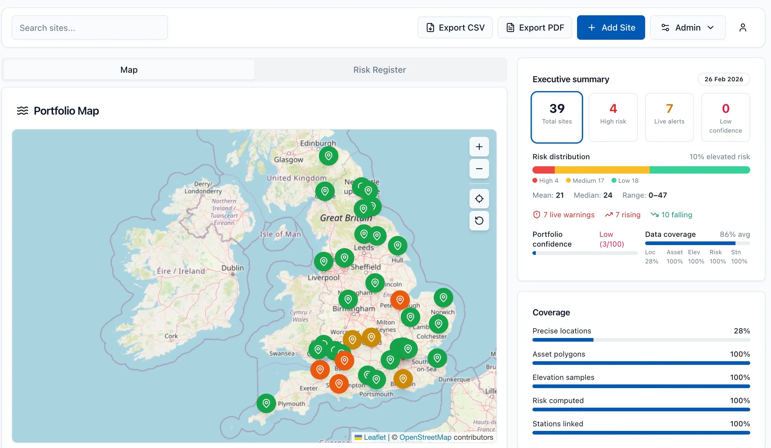
Portfolio Map
Every site on one map. Colour-coded by risk. Click to drill down into warnings, levels, and station data.
Live Flood Warnings
EA, NRW & SEPA warnings refreshed every 5 minutes. Severity badges, affected-area detail, and change detection across three nations.
River & Tidal Levels
4,000+ gauging stations with rate-of-rise alerts and rainfall accumulation. Understand the trajectory, not just the snapshot.
Risk Scoring
Every site scored 0-100 combining structural risk and live threat. Prioritise response with an explainable, continuous score.
AI Incident Briefs
One-click situation reports for leadership and response teams. What's happening, why, and what to watch — generated in seconds.
Team & Roles
Invite your team with manager, site-level, and read-only roles. Collaborate across your organisation with the right access controls.
Export & Compliance
PDF snapshots, CSV exports, and full audit trail. Every data source and decision timestamped for compliance and reporting.
Email Alerts
Severity changes trigger instant email notifications with site context and a direct link back to your dashboard.
Complete UK coverage
Official flood data from all three national agencies, unified in one consistent view.
England
Environment Agency
Flood warnings, river levels, and 4,000+ monitoring stations across all English regions.
Wales
Natural Resources Wales
Flood warnings, river and rainfall data across all Welsh local authority areas.
Scotland
SEPA
Hydrometric data including river levels, monitoring stations, and flood alerts.
Built for teams who manage portfolios
From housing associations to logistics operators — if you manage distributed sites, FloodWatch gives you operational flood visibility.
Facilities & Property
Monitor buildings and property portfolios across regions. One view for your entire portfolio.
Logistics & Field Ops
Track warehouse, depot, and distribution centre exposure to flood risk in real time.
Risk & Resilience
Evidence-based situational awareness for business continuity and insurance reporting.
Consultants
Manage flood monitoring for client portfolios efficiently. Portfolio-level visibility at scale.
See your whole portfolio in one view
Upload your sites via CSV or add postcodes individually. FloodWatch plots them on an interactive map with live severity indicators from all three national agencies.
- Interactive portfolio map with severity colours
- Site table with sortable status columns
- Drill into any site for detailed flood warnings
- Historical snapshots for audit trails
Simple, transparent pricing
Start with a 14-day free trial. No commitment required.
Essentials
For smaller portfolios
£79 /month
Up to 10 sites · 1 user
Professional
For growing teams
£249 /month
Up to 50 sites · 3 users
Intelligence
Advanced analytics
£599 /month
Up to 200 sites · 10 users
Enterprise
Custom deployments
Custom
Unlimited · SSO
All plans include a 14-day free trial. See full comparison →
Frequently asked questions
Is this a flood forecast?
Which regions are covered?
How often does data update?
What data do you store?
Can I export data?
Is there a free trial?
What counts as a site?
Important: FloodWatch is an informational tool and does not replace official flood warning services. Always follow guidance from the Environment Agency, Natural Resources Wales, and SEPA for safety decisions.
Ready to monitor your portfolio?
Start with a 14-day free trial — full access to your chosen plan. Upload your sites and see live flood status in minutes.